

The compulsions of geopolitics and the dispute over trade tariffs may have divided India and the US. Still, the new space race has once again brought them together, with the successful launch of the NISAR mission.
Four hours and twenty-two minutes after United States President Donald Trump declared a trade war with India, imposing a 25 per cent tariff on its exports, space agencies ISRO and NASA launched the world’s most powerful radar satellite in a joint mission on Wednesday evening.
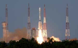
The compulsions of geopolitics and the dispute over trade tariffs may have divided India and the US—the world’s two most vibrant democracies—but the new space race has brought them together. And the convergence doesn’t stop there. The successful launch of the NASA-ISRO Synthetic Aperture Radar (NISAR) mission aboard a Geosynchronous Satellite Launch Vehicle (GSLV)-F16 rocket from the spaceport at Sriharikota off the Andhra Pradesh marks a watershed moment not just for India, but for global spacetech as well.
As the GSLV-F16 launch vehicle soared skyward in a light-yellow plume of smoke toward a Sun-synchronous orbit, it carried the two critical payloads most central to the mission: the long-band and short-band synthetic aperture radar (SAR) instruments. The data acquired through these radars will help scientists better understand Earth’s changing dynamics through NISAR.
Highlighting the mission’s importance, Vanniyaperumal Narayanan, Chairman, ISRO, and Secretary, Department of Space, said, “The NISAR satellite is a significant milestone for both the Department of Space and NASA-JPL, being the first development project undertaken by two major spacefaring nations. NISAR is an all-weather, day-and-night imaging satellite that will scan the entire Earth in a 12-day interval.”
Echoing Narayanan, Casey Swails, Deputy Associate Administrator, NASA noted, “This Earth science mission is one-of-a-kind and really shows the world what our two nations can do. But more so than that, it really is a pathfinder for the relationship building that we see across our two nations, across India and the United States, building upon decades of collaborations that already existed.”
NISAR is built around ISRO’s I-3K structure—its standard bus for 3,000 kg-class satellites—offering modular design, high payload capacity, and proven reliability for Earth observation missions. A satellite bus is the foundational platform that houses and powers all essential systems supporting the mission-specific payload.
A Billion Dollar Leap
Developed for $1.5 billion, NISAR is by far ISRO’s most expensive endeavour to date. This is a space agency otherwise known for ranking among the world’s most successful, despite operating on a shoestring budget of $1.54 billion (₹134.16 billion) in FY2026. In contrast, NASA’s budget in FY2025 was a staggering $24.8 billion. Costs for the mission have been jointly borne by NASA and ISRO, with contributions of approximately $1.2 billion and $96 million, respectively.
Among other things, the mission has once again boosted the credentials of private Indian firms developing and supplying cutting-edge solutions for ISRO’s complex space missions. Hyderabad-based Ananth Technologies Ltd (ATL), for instance, is behind the assembly, integration, and testing of various subassemblies for NISAR.
Subba Rao Pavuluri, Chairman & Managing Director of ATL, stated, “We are proud to be a major contributor in another landmark mission in India’s space journey. ISRO’s success inspires all of us in the space ecosystem to continue striving for excellence and innovation.”
Although not officially disclosed, other homegrown firms would have also contributed components and subsystems.
According to ISRO, the L-band and S-band microwave imaging systems can acquire fully polarimetric and interferometric data. The dual-band synthetic aperture radar onboard NISAR employs an advanced SweepSAR technique, enabling high-resolution imagery across large swathes of terrain. The satellite will image land masses and ice-covered surfaces, including islands, sea ice, and selected oceanic zones, every 12 days.
The mission’s core scientific objectives include monitoring land and ice deformation, terrestrial ecosystems, and dynamic oceanic regions. This will help measure woody biomass and its variations, track the spatial extent of active crop zones, assess changes in wetlands, and map the shifting ice sheets of Greenland and Antarctica, including sea ice and mountain glacier dynamics.
It will also characterise surface deformation linked to earthquakes, volcanic activity, landslides, and the subsidence or uplift associated with aquifer depletion and hydrocarbon extraction.
From Cryo Denial to Strategic Partnership
The NISAR mission is a flagship example of India-US cooperation, with complex systems developed through close coordination between ISRO and NASA. NASA has delivered the L-band radar system, high-speed downlink infrastructure, solid-state recorder, GPS receiver, and the 9-metre boom that supports the 12-metre reflector. It also provides the orbit manoeuvre and radar operations plans. ISRO is tasked with satellite command and operational control.
Ground station support from both agencies will facilitate the downloading and processing of acquired data.
The heads of leading space associations commended the mission’s success. But its deeper irony was not lost on Anil Prakash, Director General, SatCom Industry Association-India (SIA-Association), who termed it a “defining moment in global space diplomacy”.
“NISAR is also symbolic; a full-circle moment in space history. From a time when the US denied India access to cryogenic technology, we now see both nations standing shoulder to shoulder in a mission of global relevance. This isn’t about dependence, it’s about mutual respect, shared leadership, and strategic alignment between two spacefaring democracies,” declared Prakash.
Lt Gen. (Retd) Anil Kumar Bhat, Director General, Indian Space Association (ISA), said the mission’s successful execution would help take the country’s space technology industry to the next level of growth.
“The mission reaffirms India’s growing role as a trusted global space partner. As India’s private space industry also evolves, we remain committed to fostering innovative public-private partnerships that will enhance collaboration and drive the next wave of growth and value creation in the global space economy.”
This mission is the product of a decade-long journey to design, develop, and qualify some of the most advanced radar payloads and mainframe systems. The S-band SAR and L-band SAR were developed independently at ISRO and NASA’s Jet Propulsion Laboratory (JPL). Their integration within the Instrument Radar Imaging Structure (IRIS), along with associated payload elements, was tested at JPL before delivery to ISRO.
Final assembly, integration, and testing of the mainframe satellite systems took place at ISRO’s UR Rao Satellite Centre, the national space agency’s premier hub for satellite development.
Deployment Done, Discovery Awaits
But the launch and orbital deployment merely mark the completion of the first and the second phases, with two more steps remaining to be fulfilled. These are the commissioning and scientific operations phases.
In the deployment phase, the satellite’s reflector was placed in orbit 9 metres away from the satellite by a complex multistage deployable boom.
The first 90 days after launch will be dedicated to commissioning, or in-orbit checkout (IOC), to prepare the observatory for science operations. This involves initial checks and calibrations of mainframe elements, followed by JPL engineering payload and instrument checkout. The science operations phase, which begins towards the end of commissioning, will continue till the end of the mission’s life.
“The global scientific community is eagerly awaiting the satellite’s data for their respective research and usage,” said ISRO’s Narayanan.
Under a free and open data policy agreed upon by ISRO and NASA, this information will support global efforts to monitor natural disasters, environmental and ecosystem changes, climate dynamics, water and soil conditions, and urban infrastructure planning.
That is nearly everything, except monitoring the simmering trade tensions that cast their shadow on this historic partnership between the world’s two leading spacefaring nations.
-Manish Pant